*NOTE: Teacher’s guide and activity cards will be available for download here soon.
War of 1812
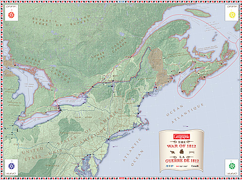
Step back in time and explore the geography of the War of 1812 on this giant floor map, which brings the three-year conflict to life across Canada and the United States. Explore major battle sites, forts, waterways, cities, and theatres of the conflict, and see how geography shaped the movement of armies, ships, and supplies. Trace routes across the Great Lakes and St. Lawrence River, locate key sites along the Canada–U.S. border, and discover how places familiar today became important settings in this pivotal chapter of North American history.
Designed to be explored on foot, the map invites students to investigate the War of 1812 from multiple perspectives and consider why particular places mattered. By examining the relationships between people, places, waterways, transportation routes, and military strategy, students can move beyond memorizing battles and dates to understand how geography influenced the course of the conflict—and how the war helped shape the future of Canada.